Road Control
Product
Planning (optimization)of routes is a highly functional calculation service that allows to determine the sequence of the most appropriate and cheap way of supplying the points of interest from a predefined depot (warehouse) using a preset fleet of company vehicles. Planning also takes the vehicle attributes (fixed costs and costs per km, capacity, requirements for safety breaks etc.) as well as attributes of specific points of interest (capacity requirements, time windows, service times) into consideration.
Description: Planning - Optimization
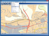
The outcome of the planning is assignment of places and their sorting into individual distribution / collection routes as well as assignment of routes to particular vehicles. Each calculated route includes basic data on costs and time, scheduled itinerary together with information on arrival / departure time, waiting times (if any) in particular places, scheduled stops etc. Routes may be displayed in the map in a simplified way or using a detailed geometry of individual distribution / collection routes.
Try 14-day trial on www.roadcontrol.eu website.
Basic attributes
- Warehouse (depot) settings - warehouse opening hours (time range).
- Multidepots support.
- Setting of places - max. 2 time windows, required capacities, service times...
- Setting of vehicles - fixed costs, costs per km, capacity...
- Vehicle type selection - calculations take vehicle profile and their restrictions into consideration.
- Multiselect - batch parameter changes.
- Minimized costs for servicing of selected places.
- Assignment of places (destinations) to particular routes and their sorting.
- Assignment of routes to vehicles.
- Dispatch advisor.
- Dima (distance matrix) cache.
- In case of a lack of vehicles, virtual vehicle is assigned.
- Identification of places out of coverage.
- The resulting plan is shown with costs, arrival and departure times, scheduled breaks and waiting times.
- Possibility of saving the entries for Planning into Favorites.
- Possibility of Plan saving (depot, places, vehicles and resulting plans) into Schedule in *.rml (XML based format).
- Possibility of Plan export into HTML or TXT formats.
- Export of individual planned routes for detailed calculation of itinerary in Route finder panel.
Description: Planning - Optimization
Attributes and options for narrowing your selection
- Place (destination) is the location of clients, service interventions, distribution points etc.
- Number of the place time windows (max. 2).
- Location and length of time window(s).
- Time spent in place of destination (service time, time of unloading/loading).
- Demand - setting of capacity (quantity) for relevant place(4 parameters: f.e. m3;l,number of pieces,kg).
- Place location (from map, from search results). Addresses or ZIP code search.
- Possibility to edit place attributes.
Attributes and options of vehicle settings
- Setting and restriction of vehicle capacity(4 parameters: f.e. m3;l,number of pieces,kg).
- Setting (restriction) of number of vehicles with identical settings.
- Fixed costs for vehicle use.
- Variable costs (per 1 km).
- Voluntary return to depot (end of route in the last visited place).
- Possibility to set the mandatory break during daytime driving.
- Restriction of total daily working hours (based on the depot time window).
Description: Planning - Optimization
Result of planning
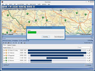
- The result of planning is shown in the solution overview. The result is also shown in the map.
- The solution overview shows both summary planning data and summary vehicle data (data for particular vehicles).
- Summary planning data: total costs, total distance of scheduled routes, number of routes, number of places not covered by service.
- Summary vehicle data: Service by vehicle - name of vehicle; costs attributable to vehicle and route assigned, serviced places - number of serviced places, total time, amount.
- During calculation the system may deal with some limiting entries that make the finding of solution impossible. In such a case the system will evaluate the situation, notify the user and adjust the entries (changes are highlighted) to find some solution.
- The map shows all calculated routes - routes for the first or any other selected vehicle are blue, other routes are grey. Every serviced place on the selected route (or by the selected vehicle) is indicated with green icon in the map and number showing the order in the sequence of servicing.
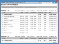
- Itinerary of each route covers: place, time of arrival, potential waiting time, if any, time of departure, the latest time of departure, distance etc. Itinerary may also show all scheduled breaks and stops.
Contact
- Martin Šimek, Optimization Solutions Manager
- mobilní telefon: +420 734 138 795
Other products
road control website
Try Road Control for FREE.
Demo Version of the product Road Control for Windows, for Europe with truck routing support. Fully functional for 14 days.
Limited for max. 5 vehicles and one simultaneously active task running by remote calculation.
Go to www.roadcontrol.eu
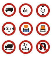
Truck attributes
Road Control offer extended 'Searching for a route' function with implementation of specific parameters and restrictions applicable to freight transport with regard to freight specification (hazardous materials, special freights) and physical attributes of vehicle (weight, height, length, number of axles…).
Screenshots...