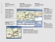
NaviGate - Desktop maps
Product
USER INTERFACE AND BASIC FUNCTIONS:
- data manager for data configuration;
- themes for easy toggling between views and data;
- control panels with information or tools;
- configurable toolbars;
- possibility to open multiple windows with various maps and tools;
- whole-screen and compact mode;
- possibility to change a general appearance of the program (skins);
- multilingual user interface (EN/CZ/SK).
- user-friendly and intuitive control allowing use of the program by wide range of users;
- dynamic zoom to display the maps at various scales;
- black & white map to highlight the displayed information;
- interactive objects in maps;
- measuring of distance, surface area and azimuth;
- localization according to coordinates set by user;
- searching of municipalities, streets, address points (Places module);
- printing and export of maps;
New functions and features are added from time to time through our extension modules.
DATABASE FUNCTIONS
Data visualization and displaying of information is ensured by interactive expression builder that contains many functions for adaptation of data to the required form. Thus it is possible to visualize almost every localized data. Also geometric functions according to OpenGIS®; (specification for working with geometric data) are available. The program further features SQL queries and also saved procedures, including integrated visual SQL query builder.
So called details may be defined for all the database objects, allowing the user for example to get more detailed information on the object (form) or execute a specific operation (open link in internet/ intranet, execute external file with parameters, etc.).
Microsoft® ADO technology is used to access file databases and database servers, allowing easy connection to all the commonly used databases (Microsoft SQL Server, MySQL, Oracle, Microsoft Access, CSV, Paradox, dBase, etc.).
LIVEUPDATE
A unique LiveUpdate function allows ongoing data displaying in cases of continuous updating of data in the database. This function is widely used in monitoring centers or in applications for visualization of equipment condition. LiveUpdate function registers adding, deletion or change of any line in the database table.
GEOCODING AND EDITING
Despite NaviGate is rather a visualization tool, it also allows users to edit and localize data in database (so called geocoding). Users can localize point objects but also more complex geometric shapes in OpenGIS® Well-Known Binary and Text (WKB, WKT)formats.
Moreover users can draw and edit vector objects (dots, lines, polygons, texts) that are saved in VED format files.
RASTER DATA FORMATS
- BMP
- NaviGate maps (.ng)
- NaviGate rasters (.ngr) (NGR module)
- GeoTIFF and TIFF (GeoTIFF module)
- ER Mapper ECW (ECW module)
- JPEG 2000 (ECW module)
- ASCII grids (Grids module)
- JPEG, PNG, GIF, PCX, TGA, ...
VECTOR DATA FORMATS
- - coordinates saved in database table (columns X, Y or more complex geometry)
- OpenGIS® Well-Known Binary and Text (WKB, WKT) formats
- VED
- MicroStation DGN, version 7 (DGN module)
- ESRI SHP
- ESRI Geodatabase
- MapInfo
- Geomedia
SYSTEMS OF COORDINATES
NaviGate supports many systems of coordinates (international WGS-84, UTM, S-42; local
S-JTSK, Gauss-Krüger, Lambert, Soldner, EOV, etc.). If necessary, more systems of coordinates may be added through extension modules.
One of the standard NaviGate features is also a concurrent visualization of data in multiple systems of coordinates (only in case of rasters, data in various systems of coordinates shall not overlap).
NaviGate API
NaviGate is also a platform for development of applications. API interface allows to create new applications or to extend the current NaviGate functions.
API helps to integrate NaviGate in the current information system of customers more efficiently or to adapt it to the specific needs of customers.
SUPPORTED OPERATION SYSTEMS
- Windows® Vista
- Windows® XP
- Windows® 2000
- Windows® NT
- Windows® 9x